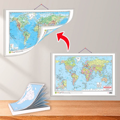
SMALL - 100 AFRICA POLITICAL OUTLINE MAP FOR SCHOOL and 2 IN 1 WORLD POLITICAL AND PHYSICAL MAP IN HINDI | Set of 1 map and 1 chart | Exploring Africa and the World A Comprehensive Map Combo Paper Print(30 inch X 20 inch)
Quick Overview
Product Price Comparison
"The combo of a Small-100 Africa Political Outline Map for Schools and a 2-in-1 World Political and Physical Map chart in Hindi provided by Gowoo offers a comprehensive educational resource for students and geography enthusiasts alike. This combination provides a diverse range of information about Africa and the world, aiding in understanding political boundaries and physical features. Measuring 7*8 inch map, and the size of the chart is 20*30. These compact maps are perfect for student use. The Small-100 Africa Political Outline Map for School is a detailed map specifically designed for educational purposes. It focuses solely on the African continent, outlining its political divisions. The map includes countries, allowing students to familiarise themselves with the political landscape of Africa. This map is an excellent tool for studying the various African nations' geography. It aids in developing a broader understanding of the continent's diversity.On the other hand, the 2-in-1 World Political and Physical Map chart in Hindi offers a broader perspective by encompassing the entire globe. This map combines two essential political and physical elements into a single resource. The political map depicts the boundaries of countries, states, and provinces worldwide. It includes the capital, major cities, and significant geographical features such as rivers, lakes, and mountains. By studying this map, students can gain insights into different regions' political divisions. This map helps students understand the Earth's diverse topography, climate patterns, and ecological regions. By examining the physical map, learners can identify the major mountain ranges, rivers, and lakes of Africa and other parts of the world, enabling a deeper understanding of the planet's natural systems.Including the Hindi language in the 2-in-1 map ensures accessibility and convenience for Hindi-speaking individuals. It makes students more comfortable studying and exploring world geography in Hindi using their native language. This feature is especially beneficial for Hindi-speaking regions and physical environments.By combining the Small-100 Africa Political Outline Map for School and the 2-in-1 World Political and Physical Map in Hindi, students gain a comprehensive and detailed resource for studying Africa and the world. This combo empowers learners to develop a broad understanding of political divisions, physical features, and cultural diversity on both a regional and global scale. Whether used in classrooms or for personal study, this combo is a valuable tool to enhance geographic knowledge and foster a deeper appreciation for our interconnected world."

